
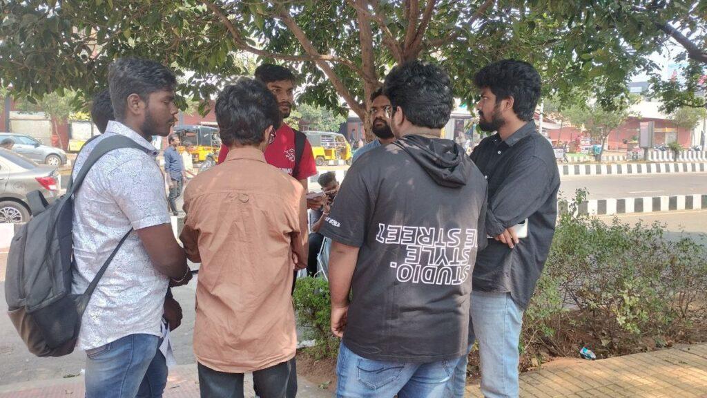
On a bright and bustling Sunday morning, a team of enthusiastic volunteers from the Swecha Learning Center (SLC) gathered in Vizag, with a common goal: to map the streets of Vizag Our mission was not just to create a comprehensive street map, but to make this data open and accessible for research, urban planning, and community development.
The Purpose Behind the Mapping Activity
In the age of information, accurate and up-to-date maps are invaluable. They serve as essential tools for urban planners, researchers, local businesses, and even residents. Despite the advancements in digital mapping, many areas, especially in rapidly growing cities like Vizag, still suffer from outdated or incomplete map data. Recognizing this gap, SLC volunteers took the initiative to conduct a one-day street mapping activity.
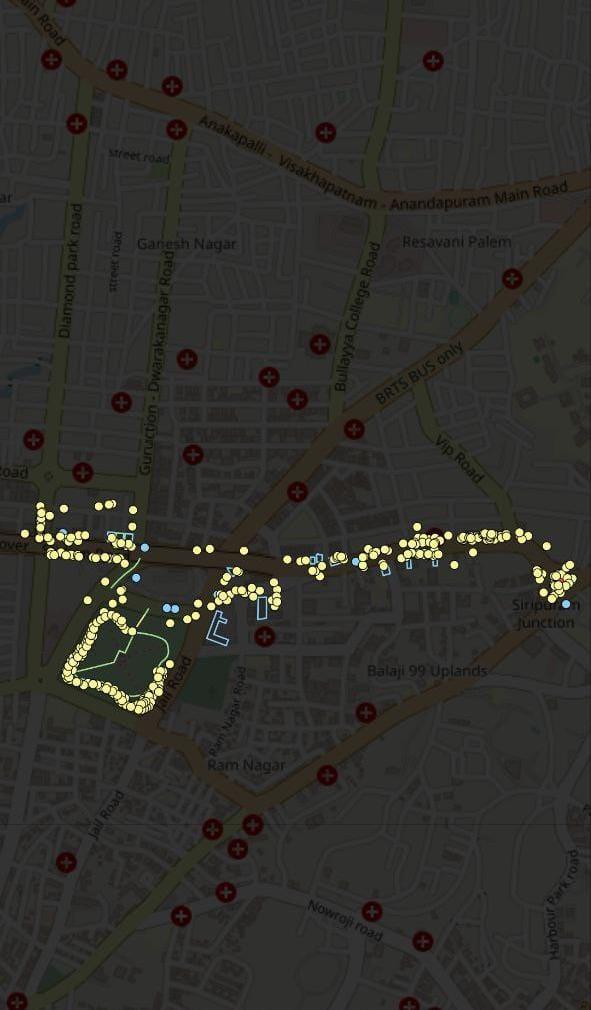
The goal was simple: to cover as much ground as possible, documenting the streets, landmarks, and other significant features, and then upload this data to an open-source platform. This effort would not only benefit the local community but also contribute to global mapping databases, aiding various research and development projects.
Preparations and Planning
Preparation for the event began weeks in advance. Volunteers were trained in the basics of mapping, using GPS devices, and mobile mapping applications like OpenStreetMap (OSM). The team was divided into smaller groups, each assigned to specific zones within Vizag to ensure comprehensive coverage.
Tools and Technology
The volunteers equipped themselves with:
- Smartphones : To record accurate geographic coordinates.
- Mapping Applications: Apps like OpenStreetMap, Mapillary, and StreetComplete.
The Mapping Day
The day kicked off with an early morning assembly at a central location. After a brief introduction and motivational speech by the SLC coordinators, the teams dispersed to their designated areas. Each team had a mix of experienced mappers and newcomers, ensuring a balance of knowledge and enthusiasm.
Mapping in Action
As the teams navigated through the streets of Vizag, they meticulously recorded every detail:
- Street Names and Landmarks: Ensuring even the smallest lanes and alleys were documented.
- Public Amenities: Locations of hospitals, schools, parks, bus stops, and other public facilities.
- Commercial Areas: Shops, markets, and businesses that form the economic backbone of the neighborhoods.
- Infrastructure Details: Information on road conditions, footpaths, and cycle lanes.
Volunteers also interacted with local residents, gathering anecdotal information and verifying the accuracy of their data. This community engagement not only enriched the mapping process but also raised awareness about the importance of open data.
Uploading and Sharing the Data
By late afternoon, the teams reconvened to compile their data. This information was then meticulously checked for accuracy and uploaded to OpenStreetMap. The result was a more detailed and accurate map of Vizag, available for anyone to use.
Benefits of Open Map Data
- Research and Development: Researchers can use the data for studies on urban development, traffic management, and environmental impact assessments.
- Urban Planning: City planners can access updated maps to design better infrastructure and public services.
- Emergency Services: Accurate maps are crucial for efficient response by emergency services like ambulances, fire brigades, and police.
- Community Empowerment: Local residents and businesses gain access to detailed information about their surroundings, fostering a sense of ownership and community pride.
Reflections and Future Plans
The one-day street mapping activity was a resounding success, thanks to the dedication and hard work of the SLC volunteers. The updated map of Vizag stands as a testament to what a committed community can achieve in just one day. Looking ahead, SLC plans to conduct similar activities in other parts of the city and beyond, continuously updating and improving the available data.
This initiative not only enhances our maps but also strengthens the bonds within our community, proving that together, we can build a better-informed and connected world.
Participants:
Sai Pahnindra
K Tanooj
Harshitha
K Mokshagna Anurag